Stormin Stofman’s: Light snow is expected this Friday
Good evening everyone, I hope that you all have had a great Thursday so far. We have our first winter storm of the season upon us in the next 24-30 hours. With the fresh injection of arctic air that came in last night, it will be cold enough to support snow at the least at the start of this event. Snow will start to break out between 10pm Friday and 2am Saturday. At the start, expect snow to be light, but pick up in intensity as the night wears on. By daybreak (4-7am) the snow should be at it’s heaviest in our area with possible rates up to an inch/hour. Between 8am-11am expect the change over to a mix of snow sleet and ice. By midday day, rain should begin to overtake the area and temperatures should begin to rise. During the afternoon Saturday, there should be a lull in the precipitation and temperatures will remain in the mid 40s. By Saturday night, the rain will begin to fall again as well during the day on Sunday. **Note** A possible changeover back to sleet/snow is possible at the tail end of this system. If that were to happen, do not expect much more than an addition inch on the back end.
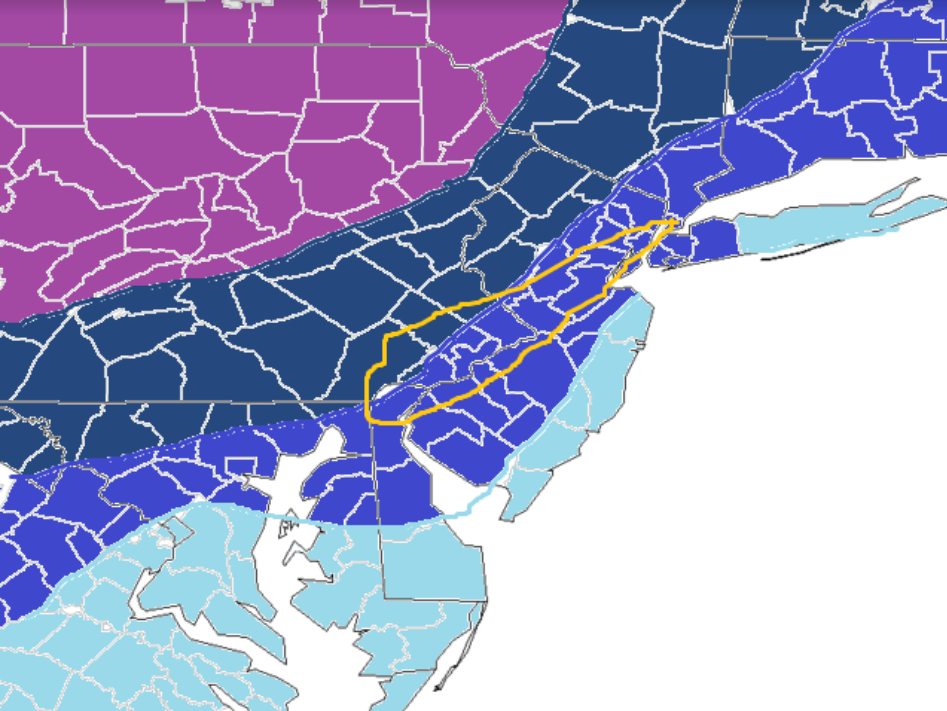
***Here is my snowfall map for this storm***
(From The Coast To PA)
Lightest Blue (DC, Shore points): Coating to an inch of snow
Second Blue (Baltimore, Cherry Hill, Philly, NYC) 1-3 inches snow
Third Blue (Lancaster, Bucks County, Allentown, Sussex): 2-5 inches of snow
Purple (CPA, NEPA): 4-7 inches of snow
Yellow Box: Wild Card (could be 1 inch could be 4. Depends on how long the cold air stays in place and front end thump potential)